
Measuring Forest Carbon Stock and Flux
Feature Article for 2021-2022, by Emily Hightower
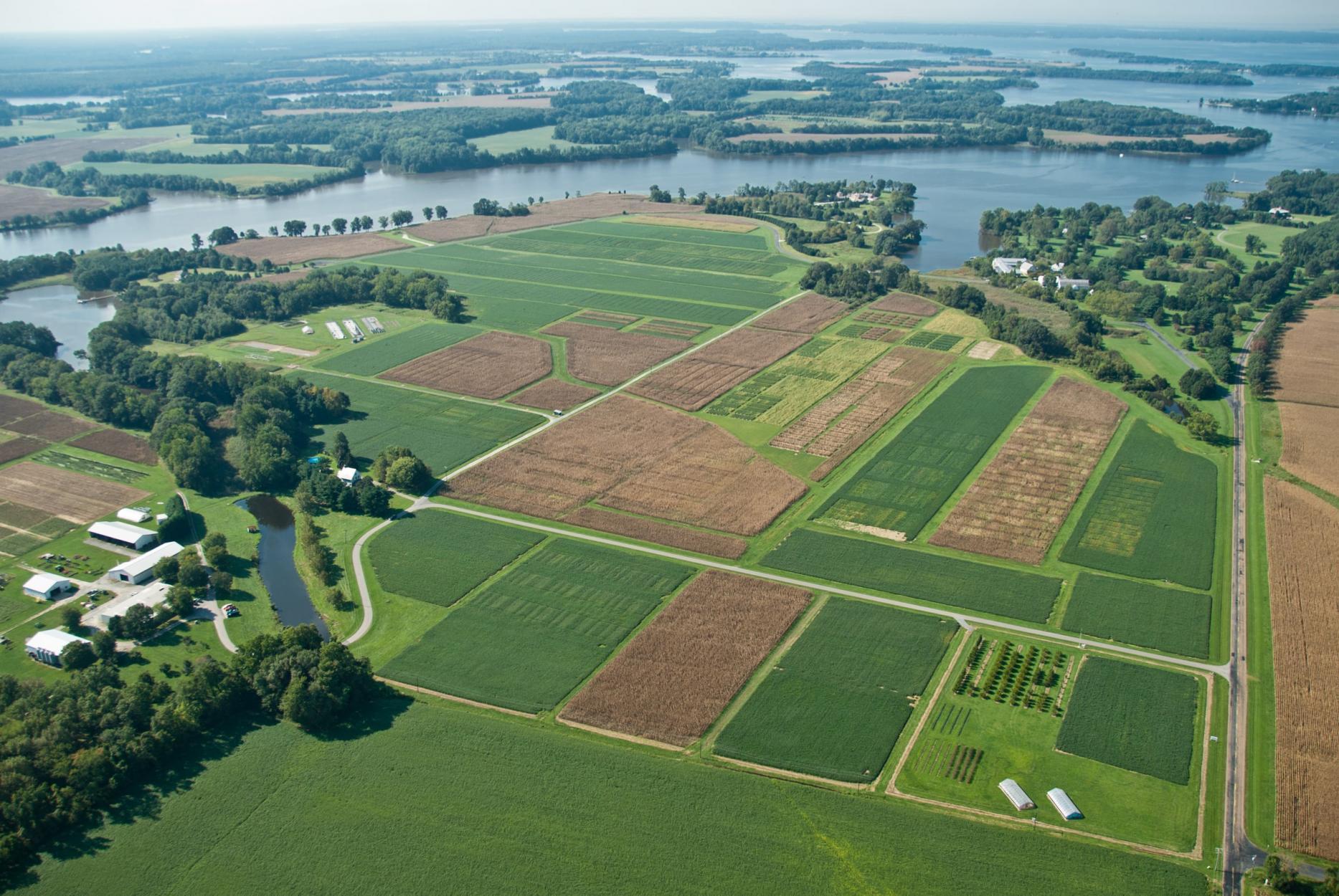
With over 5,000 acres of land across the state of Maryland, the University of Maryland College Park’s campuses are abundant in natural spaces and forested areas. The main campus in College Park is an internationally accredited arboretum with over 15,000 trees, more than 60 acres of protected forest easement, and an Audubon Certified Sanctuary Golf Course. Satellite campuses around the state include over 2,500 acres of farmland, agricultural research stations, fire safety and training facilities, and a bioscience research complex.
These green spaces provide important benefits to mental and physical health, education, and campus operations. They provide enormous environmental benefits ranging from storm protection to energy conservation, from wildlife sanctuaries to carbon storage. As part of the University’s 2015 Climate Action Plan, the university committed to studying these natural landscapes to better understand the carbon sequestered and stored by forests on campus.
Forests—and the carbon they sequester as part of the natural carbon cycle—were a primary focus of the 2021 United Nations Climate Change Conference. In the Glasgow Leaders’ Declaration on Forest and Land Use, more than 141 countries pledged to a sustainable land use transition, committing to halt and reverse deforestation and land degradation, conserve coastal wetlands and peatlands, and generally conserve global ecosystems and biodiversity.
Each of the sections below capture UMD’s efforts to progress forest carbon monitoring at the university, state, national, and international levels.
- Students Calculate Campus Forest Carbon Flux: Students at UMD combine research from multiple university departments and disciplines to create a process for capturing and monitoring trends in campus forest carbon storage. Their methodology for campus mirrors faculty efforts to monitor State of Maryland forest carbon and support international forest carbon research.
- UMD Partners to Monitor Global Forest Carbon: Researchers from UMD guide scientific and political efforts to monitor global, national, regional, state, and local forest carbon stocks and future forest carbon storage potential. Through interdisciplinary research and collaboration, advancements in satellite imagery and data storage, and emerging climate science, UMD researchers are helping governments—like the State of Maryland—implement solutions to humanity's grand challenges.
- Forest Carbon Storage in University Climate Action Planning: Future campus policies and strategic plans will consider campus forest carbon storage and the implications of reforestation, deforestation, and other land-use changes. UMD is the first university to use remote-sensing data to calculate forest carbon flux.
Students Calculate Campus Forest Carbon Flux
Leveraging student academic and research expertise to accelerate campus climate action
With grant funding from the Sustainability Fund, student researchers from the Department of Geographical Sciences developed a methodology using the “latest remote sensing techniques to estimate and include land-based carbon sequestration in UMD’s greenhouse gas inventory.” In combining the student estimates of aboveground biomass carbon storage with the university’s data on greenhouse gas emissions from campus operations, the university can better calculate the net greenhouse gas emissions footprint of campus. The student model further quantifies the importance of green spaces on campus and allows the university to understand the implications of deforestation, reforestation, and other land-use changes on the university’s carbon footprint.
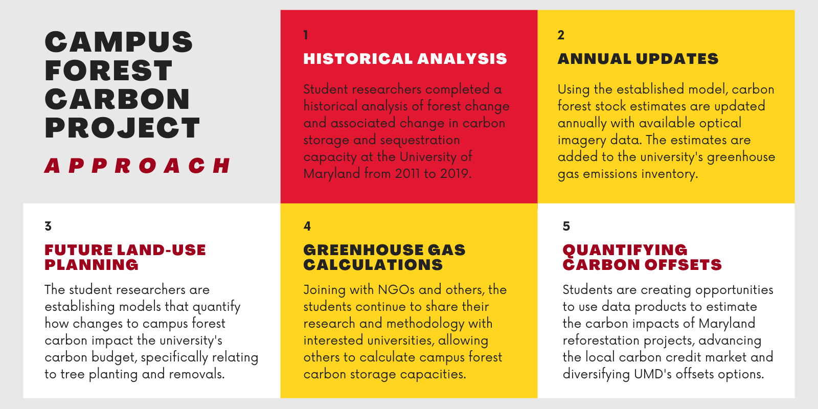
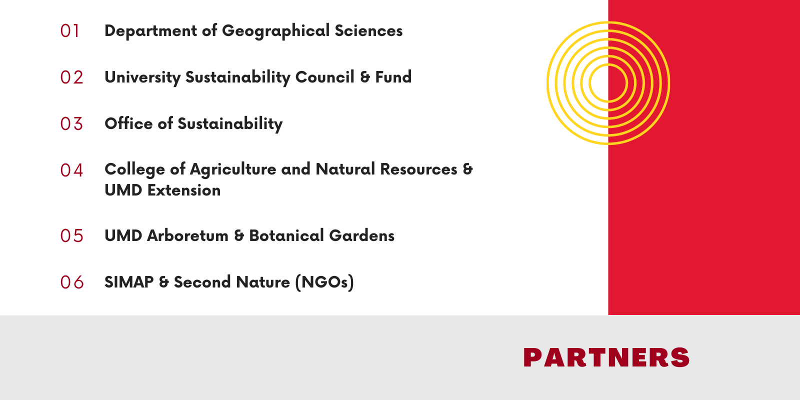
In their methodology, the students leverage national research to address and solve grand challenges at the campus level: high resolution (90-meter) estimates of current above-ground biomass (ABG) and carbon sequestration potential from NASA Carbon Monitoring System (CMS) products; data on tree cover and canopy height from LiDAR and NAIP optical imagery; and the Ecosystem Demography (ED) model. The ED model projects the growth of existing trees and the carbon provided by newly planted trees and is based on research by UMD faculty and staff in the Department of Geographical Sciences. Field data from the US Forest Service and the UMD Arboretum and Botanical Gardens verifies the campus forest carbon estimates derived from the student methodology. After generating and verifying the data, the student methodology plots ABG gains and losses on UMD land property maps, capturing forest carbon flux in aggregate and by location which allows analysis of major gains and losses by property. The student methodology was established by leveraging efforts by UMD researchers and NASA-CMS scientists to calculate forest carbon sequestration, storage, and potential for the State of Maryland greenhouse gas emissions inventory. The data generated by the student team will provide a subset of the State of Maryland's total forest carbon flux, data specific to the forests on University of Maryland properties.
The student researcher team has included more than ten students over the span of the project. Their contributions include research; data collection and organization; modeling; GIS-analysis; data visualization; peer-verified carbon offset protocol development; and a variety of other tasks. Equipped with invaluable skills developed through the experiential project, students that joined as juniors and seniors in the first year of the project have graduated to careers such as Environmental Impact Manager at a reforestation company and GIS Analyst at USDA. Others have pursued graduate degrees in geographical sciences and medical geography. Current undergraduate students involved in the project have also become involved with the Sustainability Fund Student Review Committee, the Student Government Association Sustainability Committee, and other notable groups on campus. The project’s first graduate assistant was awarded the Maryland Sea Grant State Science Policy Fellowship at the Maryland Department of the Environment after receiving a doctorate from UMD. The following graduate assistants previously worked on the project as undergraduates and pursued Masters of Science in Geographical Sciences at UMD. All are working with nonprofits, researchers, and politicians to help shape the future of forest carbon monitoring at local, state, national, and international levels.
Throughout the project, the students have developed materials for other students, technical experts, and the general public. Explore some of the resources below to learn more about the Campus Forest Carbon Project and the team of students guiding this effort.
Alignment with UN Sustainable Development Goals
 |  |  |
Learn more about these Global Goals
| Navigate: | To the article contents |
UMD Partners to Monitor Global Forest Carbon
Research, scholarship, and policy to help solve one of humanity's great challenges
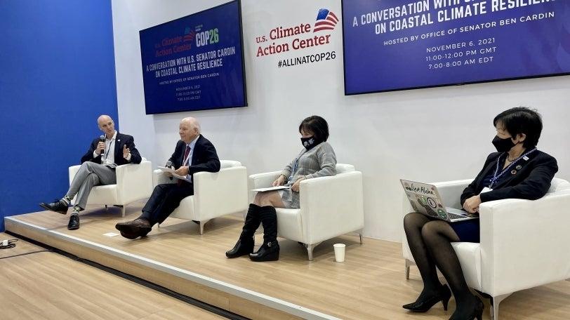
In November 2021, global leaders gathered in Glasgow, Scotland, for the 26th United Nations Climate Change Conference. Over 13 days, delegates and leaders from more than 194 countries discussed the urgent climate crisis with countries sharing new reductions targets and agreeing to new commitments like the Glasgow Climate Pact. As part of this agreement, leaders from countries containing more than 90% of the global forests committed to halt and reverse forest loss and land degradation by 2030. Faculty from the University of Maryland are leading and participating in the efforts to monitor forest carbon at international, federal, state, and local levels.
UMD researchers have studied global ecology and carbon flux for decades, participating in the development of the GEDI and ICESat-2 high-resolution Light Detection and Ranging (LiDAR) datasets and the creation of essential climate models like the Ecosystem Demography (ED) model, the Global Land-Use Model (GLM) and the Land-Use Harmonization (LUH) models. In global partnership, scientists can now use this research to monitor the carbon released due to deforestation and the carbon drawdown from forest regrowth and planting. New partnerships are forming to establish field-verified data using 3D scans of trees and species inventories. Including this field-verified data will better capture regional differences and improve global forest carbon calculations. UMD researchers and partners also aim to make forest data and computing power more accessible to public entities like local governments so that they can plan effectively, contribute to global forest goals, and measure their progress. The Campus Forest Carbon Project team provides an example of scientists applying these international models and datasets to a local study of UMD’s forest carbon flux.
NASA Carbon Monitoring System
Prototyping the capabilities to support monitoring, reporting, and verification (MRV) of carbon stocks and fluxes
State of Maryland Carbon Monitoring
High-resolution maps of aboveground biomass, carbon sequestration, landcover and forest structure
ICESat-2
International Earth-observing satellite mission to collect data on ice sheet elevation and other arctic data
Global Ecosystem Dynamics Investigation
High-resolution laser ranging of Earth's forests and topography from the International Space Station (ISS)
Global Land Analysis and Discovery
The GLAD Global Forest Monitoring Project extends global forest cover dynamics and land cover change estimation
Joint Global Carbon Cycle Center
"A world-leading center for the studies of the global carbon cycle"
At COP26, Maryland Secretary of the Environment Ben Grumbles announced that the State will use "first-of-its-kind" satellite data to monitor the carbon stock and flux associated with Maryland's forests. In the 2030 Greenhouse Gas Reduction Act, the State of Maryland commits to reforesting over 68,500 acres of land and planting 7.25 million trees by 2030 (with over 2.65 million trees in urban spaces). Using the new technology, the state can evaluate carbon sequestration by forests and track progress toward tree planting and greenhouse gas reduction goals. UMD is a participant in Maryland's statewide goals and is aligning campus-level forest monitoring with the technology to which Secretary Grumbles has committed. This technology was developed in partnership with faculty from the University of Maryland and funded by NASA. Other governmental entities also participated, including the Maryland Department of the Environment, Maryland Department of Natural Resources, Delaware Department of Natural Resources and Environmental Control, and the World Resources Institute.
Alignment with UN Sustainable Development Goals
 |  |  |
Learn more about these Global Goals
| Navigate: | To the article contents |
Forest Carbon Storage in UMD Climate Action Planning
Implementing student solutions on UMD's green living-learning-laboratory campus
The Campus Forest Carbon Project completed an extensive inventory of UMD's main and satellite campuses and calculated the current and historic forest carbon flux. In fall 2022, the University of Maryland's Office of Sustainability included these calculations for the first time in the 2021 greenhouse gas inventory report. UMD is the first university in the nation to use remote-sensing data to calculate campus forest carbon flux for its greenhouse gas emissions inventory.
Using the same technologies, data, and models as the State of Maryland and international communities, these students have identified trends in campus forest carbon activities. They have identified opportunities to increase carbon sequestration on campus through planting and management and determined the cause of carbon disturbances. Overall, they found that campus is a carbon sink -- it absorbs more carbon through forests than what is lost due to tree removal or disturbance. Moving forward, the university plans to include these calculations in the greenhouse gas emission inventory annually. UMD will also explore how to incorporate carbon storage potential and relevant strategies into the climate action plan. Explore some of the findings below to learn about the carbon storage of UMD's campus forest.
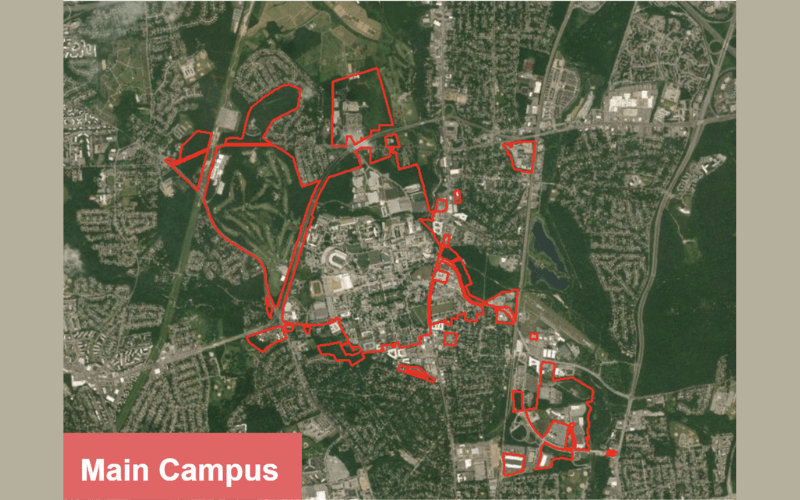
Main Campus - 2020
This map outline UMD's properties in College Park including main campus, the Golf Course, the Paint Branch Turfgrass AGNR Research and Education Center, the Seneca and Severn Buildings, and the Discovery District. Satellite imagery indicates high levels of development in the main campus and Discovery District property boundaries.
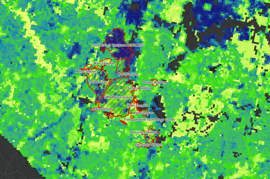
Carbon Storage Potential Gap - Optimal Range
In this map, the range of the carbon storage potential gap (CSPG) is highlighted per 90-m resolution for main campus. The dark blue highlights areas where there is a large opportunity to reforest and increase carbon storage while yellow shows areas with low CSPG. This model considers impervious surface and buildings.
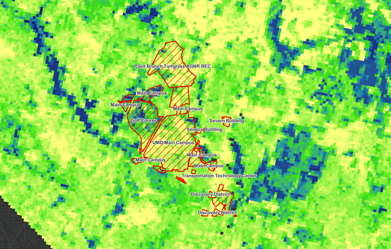
Aboveground Biomass (ABG) - 2012
This map captures the aboveground biomass of campus in 2012. Notice that some areas have higher concentration of ABG, for example the Turfgrass facility and Golf Course, as highlighted by the dark blue pixels. Compared to 2020, there was less ABG on main campus in 2012.
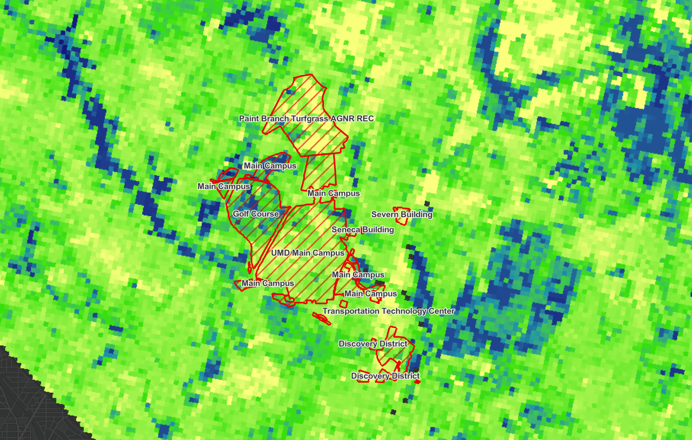
Aboveground Biomass (ABG) - 2020
This map captures the aboveground biomass of main campus in 2020. Compared to 2012, campus is generally more forested and stores more carbon in natural spaces (dark blue and green pixels). Though there was progress on main campus, development in the Discovery District and other locations impacted historical carbon storage trends.
In addition to supporting UMD operations, the Campus Forest Carbon Team has presented to other universities and higher education groups. The students aim to share their research and encourage other students and universities to complete similar studies. For example, the students have presented to the Second Nature Bioenergy & Land Use Work Group, the American Forest Foundation, the Chesapeake Bay Foundation, and the American Geophysical Union. By incorporating campus forest carbon into their greenhouse gas emissions inventory, universities can better understand the implications and costs of land use change and development on campus. Another subset of the project focuses on making this methodology available to other universities for peer-reviewed offset verification. While these offsets would only apply to Scope 3 emissions, the peer verification process is far less time and cost intensive. This would allow local small land owners the opportunity to explore the feasibility of reforestation in their area in partnership with local colleges and universities to offset commuting and air travel emissions.
Alignment with UN Sustainable Development Goals
 |  |  |
Learn more about these Global Goals
| Navigate: | To the article contents |
